Search This Blog

Saturday, 26 May 2018

FORESTS IN THE OLDEST CYCLES OF RIGVEDA

Another solid article from Dr. Semenenko

Семененко А.А.
Gymnasia No 2, Voronezh, Russia
FORESTS IN THE OLDEST CYCLES OF RIGVEDA.
Abstract. The article deals with the description of forests and trees in the most archaic parts of Rigveda (Mandalas II-VII and IX). The author demonstrates that the Rigvedic Indo-Aryans lived in immediate proximity of the forests, visited them regularly, used them as source of wood and food, gave names to at least five of the endemic trees of Hindustan, divinized and worshipped trees and considered them aspects of the Divine Mother and Devas.
Key words: Rigveda, Indo-Aryans, forests, trees, Ashvattha, Harappa.

 The translator of Rigveda [1] (further RV) into Russian T.Ya. Elizarenkova is an adherent of the Aryan Invasion/Immigration Theory and as such she states that Rigvedic Indo-Aryans (further IA) entering Hindustan were mostly nomads previously living in the vast open spaces of the Eurasian steppe. Speaking of the forests’ role in life of RV authors she writes: “Aryans of RV knew of the forests but they had not yet made use of them. The term vána- seldom means ‘forest’ in this text. Forest was thought of as something remote and unfamiliar. It was contraposed to home/a house (amā́, dáme) and to a village (grā́me)... This opposition is a variant of a more generic one: ‘own’ - ‘alien’ or ‘inner’ - ‘outer’. When the term vána- is used in RV in the sense of the ‘forest’ in most cases it means a place which scares and which is attacked by the Aryan gods (Agni, Indra, Maruts). Unlike water and mountains forests in RV were not associated with the gods… Long time passed before Aryans gradually made use of the forests… It happened in the period following great Vedic collections - Samhitas… Forests are poorly represented in RV… Both rivers and mountains were divinized and reflected in mythology. There was no place for forest in it. RV preserves the names of sacred and profane trees of different species (sometimes they are of local origin)” [2].
Let us see what the most archaic cycles of RV (Mandalas II-VII and IX) tell us about the forests. As far as is known forest is made up of trees. And trees are abundantly and with the use of different words mentioned in the most ancient parts of RV: big trees (vánaspátīn) - 19 times (II.3.10; III.4.10; III.8.1, 3, 6, 11; III.34.10; V.7.4; V.5.10; V.41.8; V.42.16; V.78.5; V.84.3; VI.15.2; VI.48.17; VII.2.10; VII.34.23; IX.5.10; IX.12.7), ordinary trees - 43 times (II.1.1; II.4.5, 6; II.14.2; II.31.1; II.39.1; III.23.1; III.45.4; IV.20.5; V.1.5; V.11.6; V.41.10, 11; V.54.6; V.57.3; V.58.6; V.60.2; V.78.6; V.83.2; V.85.2; VI.2.9; VI.3.5; VI.6.3; VI.8.5; VI.13.1; VI.18.10; VI.24.3; VI.33.3; VI.39.5; VI.48.5; VI.57.5; VI.60.10; VII.4.2, 5; VII.7.2; VII.34.25; VII.35.5; VII.43.1; VII.56.25; VII.95.5; IX.72.5; IX.96.6; IX.97.53), forests (following the very translation of T.Ya. Elizarenkova) - 13 times (II.38.7; III.6.7; III.34.3; III.51.5; IV.7.1, 6; V.41.11; V.78.8; VI.12.3; VI.31.2; VII.1.19; IX.33.1; IX.92.6). It is evident that numerous trees were integral and very well known element of Rigvedic landscape already during the earliest period of Mantras’ composition. Forests around the poets of RV were so large that they were afraid to get lost in them (mā́ no vána ā́ juhūrthāḥ) (VII.1.19).
T.Ya. Elizarenkova’s statements about the poor forests’ representation in RVedic religion and mythology also disagree with RV information. We learn that Indra seized big trees (índra vánaspátīm̐r asanod) (III.34.10) and is identified as an ordinary tree (vr̥kṣásya nú te puruhūta vayā́ ví ūtáyo ruruhur indra pūrvī́ḥ) (VI.24.3), that Soma is the lord of the trees or a big tree himself (vánaspátir) (IX.12.7), that Agni’s boons come out of him as branches out of an ordinary tree (tuvád víśvā saúbhagāni ágne ví yanti vaníno ná vayā́ḥ) (VI.13.1). It was under the big trees where Rigvedic Aryans sacrificed (II.3.10; III.4.10; V.5.10; VII.2.10; IX.5.10). Big trees were used to produce and erect sacrificial posts identified with them (III.8.1-4, 6-11).
It is contrary to T.Ya. Elizarenkova’s words that only big trees were considered sacred [3] that Indra is called an ordinary tree (vr̥kṣásya), that Agni is compared to an ordinary tree (vaníno), that Ashvins are described as commanding not only big but also an ordinary tree: ví jihīṣva vanaspate yóniḥ sū́ṣyantiyā iva | śrutám me aśvinā hávaṃ saptávadhriṃ ca muñcatam || bhītā́ya nā́dhamānāya ŕ̥ṣaye saptávadhraye | māyā́bhir aśvinā yuváṃ vr̥kṣáṃ sáṃ ca ví cācathaḥ ‘O tree (vanaspate), spread apart, like the womb (yóniḥ) of a woman about to give birth (sū́ṣyantiyā). Hear my call, Aśvins, and free Saptavadhri. || For the seer Saptavadhri, who is fearful and in need, o Aśvins, you bend the tree (vr̥kṣáṃ) together and apart by your cunning’ (V.78.5-6) [4]. Also we see in the last verses the identification of a tree with a woman-giving-birth [5] which means that for the Rigvedic IA tree was an aspect of the Divine Mother.
T.Ya. Elizarenkova’s words that only big trees were considered sacred disagree with the fact that RV contains stereotyped prayers to big (vánaspátīm̐r, vánaspátibhiḥ) and ordinary (vaníno) trees (námobhir vánaspátīm̐r óṣadhī rāyá éṣe (V.41.8), praíṣá stómaḥ vánaspátīm̐r óṣadhī rāyé aśyāḥ (V.42.16), tán no rā́yaḥ óṣadhīr utá vánaspátibhiḥ || rāyáḥ siyāma dharúṇaṃ dhiyádhyai || tán na óṣadhīr vaníno juṣanta (VII.34.23-25), śáṃ na óṣadhīr vaníno bhavantu (VII.35.5)). It seems indeed very strange for the people unfamiliar with forests not only to compose such prayers but also to ask ordinary trees for blessings while moving into a new locality (apó yéna sukṣitáye tárema ádha svám óko abhí vaḥ siyāma || tán na óṣadhīr vaníno juṣanta) (VII.56.24-25).
All these facts point to an active use of forests already in the period of composing of the earliest hymns of RV which is further proved by mentions of timber cutting (VI.8.5; IX.96.6) and fruit gathering (III.45.4; IX.97.53) in the forests and burning wood in the process of metal smelting (dravír ná drāvayati dā́ru dhákṣat) (VI.3.4).
Trying to give us evidence of the Rigvedic IA’s poor knowledge of the forests T.Ya. Elizarenkova informs us that ‘RV preserves the names of sacred and profane trees of different species (sometimes they are of local origin)’. But what she ‘forgets’ to make clear is that the endemic trees of the South Asia (khadirá (Acacia Catechu), spandaná (Diospyros embryopteris) and śiṃśápā (Dalbergia Sissoo)) are enumerated as a source of wood to produce the wheeled vehicles only in one of the Family Cycles (Mandalas II-VII) of the Samhita (III.53.19) and nowhere else in it and that RV knows not of any of the out-of-India tree species... The very same hymn mentions the cutting down of one more local tree Bombax heptaphyllum L. or Salmalia malabarica named śimbalá or śalmalí (paraśúṃ cid ví tapati śimbaláṃ cid ví vr̥ścati) (III.53.22) [6]. Poison of Salmalia malabarica is also mentioned in the other Family Mandala of RV (yác chalmalaú bhávati viṣám) (VII.50.3). A die made of an oval nut of the large tree Terminalia bellerica (vibhī́dako) is described in the same Mandala (VII.86.6) [7]. And again next Family Cycle speaks of the big tree Kakambira (mā́ kākambī́ram úd vr̥ho vánaspátim) (VI.48.17). Although it is not identified [8] its name is evidently local.
Maruts are described as flipping off the sky a berry (nā́kam rúśat píppalam maruto ví dhūnutha) (V.54.12) but whether this berry (píppalam) belongs to the famous South Asian tree aśvatthá (Ficus religiosa or Ficus peepul) can’t be said with certainty. J. McIntosh writes of the cult of this tree in the North-Western Hindustan during the Mature Harappan epoch (2600-1900 BCE): ‘A number of tablets show an individual with a pot, apparently making an offering to a tree, usually a pipal. A few seals show figures that may be identified as gods and goddesses inside these trees, particularly the pipal, or under an arch of pipal leaves. These leaves had been a familiar decoration on pottery of the northwest since much earlier times; they were often combined with the horns of bulls or water buffaloes, and together they form headdresses worn by a number of deities’ [9]. But this tree is surely spoken of in the most modern cycles of RV: átrā́ha tád vahethe mádhva ā́hutiṃ yám aśvatthám upatíṣṭhanta jāyávo (I.135.8), vr̥kṣám pári ṣasvajāte | táyor anyáḥ píppalaṃ svādú átti (I.164.20), vr̥kṣé tásyéd āhuḥ píppalaṃ svādú ágre (I.164.22), óṣadhīr mātaras devīr || aśvatthé vo niṣádanam parṇé vo vasatíṣ kr̥tā́ (X.97.4-5) [10].
So we see that the earliest part of RV enumerates five (or may be six) endemic trees of the South Asia - khadirá (Acacia Catechu) (III.53.19), spandaná (Diospyros embryopteris) (III.53.19), śiṃśápā (Dalbergia Sissoo) (III.53.19), śimbalá or śalmalí (Bombax heptaphyllum или Salmalia malabarica) (III.53.22; VII.50.3),vibhī́daka (Terminalia bellerica) (VII.86.6) and aśvatthá (Ficus religiosa) (V.54.12) (a case in dispute).
It should be noted especially that the authors of the Mandalas II-VII and IX know not of Ficus religiosa, the cult of which was widely spread in their habitat in III Millennium BCE. This makes us date the core of RV several centuries prior to 2600 BCE at least for IA while entering Hindustan in the III or II Millennium BCE should have learnt of that most venerable local tree at once and mention its name already in the most archaic cycles of RV. That IA learnt at once the names of the endemic trees of the South Asia is proved by the fact of inserting the names of local trees - khadirá (Acacia Catechu), spandaná (Diospyros embryopteris), śiṃśápā (Dalbergia Sissoo), śimbalá or śalmalí (Bombax heptaphyllum or Salmalia malabarica), vibhī́daka (Terminalia bellerica) - already in the Family Mandalas of the Samhita. The fact that IA mentioned the name of Ficus religiosa only in the first and the tenth Mandalas makes it clear that Mandalas II-IX were composed several centuries before 2600 BCE, while Mandalas I and X were added about 2600 BCE and reflected the widespread cult of this tree in Early Harappan and Mature Harappan culture of Hindustan of the III Millennium BCE.
So we see that already in the period of composing of the most archaic parts of RV (cycles II-VII and IX) IA lived in immediate proximity of the forests, visited them regularly, used them as source of wood and food, gave names to at least five of the endemic trees of Hindustan, divinized and worshipped trees and considered them aspects of the Divine Mother and Devas. This disproves the Aryan Invasion/Immigration Theory and supports the autochthonous origin of the Rigvedic IA in the North-Western South Asia. 
Список литературы
1. Ригведа. Изд. подг. Т.Я. Елизаренкова. В 3 тт. - М.: Наука, 1989-1999; Rigveda. Metrically Restored Text. Eds. K. Thomson & J. Slocum // [Электронный ресурс:] http://www.utexas.edu/ cola/centers/lrc/RV/.
2. Елизаренкова Т.Я. Слова и вещи в Ригведе. - М.: Наука. Издательская фирма «Восточная литература» РАН, 1999. - С. 109-110.
3. Ibid. - С. 109.
4. The Rigveda. The earliest religious poetry of India. Tr. by S.W. Jamison & J.P. Brereton. - Oxford-NY: Oxford University Press, 2014. - P. 761.
5. Елизаренкова Т.Я. Примечания // Ригведа. Мандалы I-IV. Изд. подг. Т.Я. Елизаренкова. - М.: Наука, 1989. - С. 714; Przyluski J. Non-Aryan Loans in Indo-Aryan // Lévi S., Przyluski J., Bloch J. Pre-Aryan and Pre-Dravidian in India. Tr. from French by P.Ch. Bagchi. - New Delhi-Madras: Asian Educational Services, 2001. - P. 6-8.
6. Macdonell A.A., Keith A.B. Vedic Index of Names and Subjects. Vol. II. - L.: John Murray, 1912. - P. 303; Елизаренкова Т.Я. Примечания // Ригведа. Мандалы IX-X. Изд. подг. Т.Я. Елизаренкова. - М.: Наука, 1999. - С. 442.
7. Елизаренкова Т.Я. Примечания // Ригведа. Мандалы V-VIII. Изд. подг. Т.Я. Елизаренкова. - М.: Наука, 1999. - С. 598.
8. McIntosh J. The ancient Indus valley: new perspectives. - Santa Barbara: ABC-CLIO, 2008. - P. 284-285.
9. Macdonell A.A., Keith A.B. Vedic Index of Names and Subjects. Vol. I. - L.: John Murray, 1912. - P. 43-44.
 Yog (Page 331).

Saturday, 31 March 2018

Harvard's ''Genomic Formation of South and Central Asia ''

So here we have an aDNA paper from Narasimhan et al , published at bioRxiv today. It is a big paper, containing more than 350 ancient samples, from important ancient sites of Central Asia ,Iran and also S Asia. The apparent impression from the first read is that, they have found ''evidence'' of migration from Steppe to S Asia. They don't have Mature Harappan samples, which is a shame.The S Asian samples are from Swat/Pakistan dating from only around 1200 bce to historical period. In those samples they have found no R1a except a singleton R1a from Saidu_Sharif_IA I6891 (500-300 BCE) .The archaeological  studies from the past have shown that Swat culture had largely female centered characteristics rather than the expected opposite , see here for example.The importance of feminine  is also reflected in modern culture of Kalash also, like freedom of women, and goddess cult, see here.
Interestingly, they have ruled out BMAC as potential source population of S Asians, this goes against the traditional AIT model . I am suspecting for example, the West Siberian HG ancestry they have discovered is actually Central Asian HG component ,which included N India.In the BMAC main cluster they measure this ancestry at 13%, but in Sarazm EN , it had around 25% presence(just as in the samples from Pakistan!, suggesting dilution by West Asian migration rather than what they imply.) , in their qpAdm based analysis(p.22 main paper) we only see the green Siberian HG ancestry appearing in ancient S Asians, while EHG related one is absent. From main paper p.9:
Third, between 3100-2200 BCE we observe an outlier at the BMAC site of Gonur, as well as two outliers from the eastern Iranian site of Shahr-i-Sokhta, all with an ancestry profile similar to 41 ancient individuals from northern Pakistan who lived approximately a millennium later in the isolated Swat region of the northern Indus Valley (1200-800 BCE). These individuals had between 14-42% of their ancestry related to the AASI and the rest related to early Iranian agriculturalists and West_Siberian_HG.
There cannot be any doubt that this West_Siberian_HG-related ancestry was in  N India since at least 3000 BCE, but probably much earlier. Also finding ancestry related to ''S Asian HG''s may imply, that it was  also well present in N India prior to 2000 bce , but was it uniformly present? only aDNA from India will clarify.Their argument is mainly based on the samples like  Gonur2_BA migrant being representative of the whole SSVC population!. But in near future, if we get samples from SSVC proper and they show  strong relation to the SPGT samples, the whole argument falls.They also didn't find the S Asia specific R1a-L657, in any of their ancient samples ...

The Genomic Formation of South and Central Asia
            Vagheesh  M Narasimhan et al.
doi: https://doi.org/10.1101/292581
Abstract
The genetic formation of Central and South Asian populations has been unclear because of an absence of ancient DNA. To address this gap, we generated genome-wide data from 362 ancient individuals, including the first from eastern Iran, Turan (Uzbekistan, Turkmenistan, and Tajikistan), Bronze Age Kazakhstan, and South Asia. Our data reveal a complex set of genetic sources that ultimately combined to form the ancestry of South Asians today. We document a southward spread of genetic ancestry from the Eurasian Steppe, correlating with the archaeologically known expansion of pastoralist sites from the Steppe to Turan in the Middle Bronze Age (2300-1500 BCE). These Steppe communities mixed genetically with peoples of the Bactria Margiana Archaeological Complex (BMAC) whom they encountered in Turan (primarily descendants of earlier agriculturalists of Iran), but there is no evidence that the main BMAC population contributed genetically to later South Asians. Instead, Steppe communities integrated farther south throughout the 2nd millennium BCE, and we show that they mixed with a more southern population that we document at multiple sites as outlier individuals exhibiting a distinctive mixture of ancestry related to Iranian agriculturalists and South Asian hunter-gathers. We call this group Indus Periphery because they were found at sites in cultural contact with the Indus Valley Civilization (IVC) and along its northern fringe, and also because they were genetically similar to post-IVC groups in the Swat Valley of Pakistan. By co-analyzing ancient DNA and genomic data from diverse present-day South Asians, we show that Indus Periphery-related people are the single most important source of ancestry in South Asia — consistent with the idea that the Indus Periphery individuals are providing us with the first direct look at the ancestry of peoples of the IVC — and we develop a model for the formation of present-day South Asians in terms of the temporally and geographically proximate sources of Indus Periphery-related, Steppe, and local South Asian hunter-gatherer-related ancestry. Our results show how ancestry from the Steppe genetically linked Europe and South Asia in the Bronze Age, and identifies the populations that almost certainly were responsible for spreading Indo-European languages across much of Eurasia.

Yog

Friday, 9 March 2018

Intensified summer monsoon and the urbanization of Indus Civilization in northwest India

Yama Dixit, David A. Hodell, Alena Giesche, Sampat K. Tandon, Fernando Gázquez, Hari S. Saini, Luke C. Skinner, Syed A. I. Mujtaba, Vikas Pawar, Ravindra N. Singh & Cameron A. Petrie
Abstract
Today the desert margins of northwest India are dry and unable to support large populations, but were densely occupied by the populations of the Indus Civilization during the middle to late Holocene. The hydroclimatic conditions under which Indus urbanization took place, which was marked by a period of expanded settlement into the Thar Desert margins, remains poorly understood. We measured the isotopic values (δ18O and δD) of gypsum hydration water in paleolake Karsandi sediments in northern Rajasthan to infer past changes in lake hydrology, which is sensitive to changing amounts of precipitation and evaporation. Our record reveals that relatively wet conditions prevailed at the northern edge of Rajasthan from ~5.1 ± 0.2 ka BP, during the beginning of the agricultural-based Early Harappan phase of the Indus Civilization. Monsoon rainfall intensified further between 5.0 and 4.4 ka BP, during the period when Indus urban centres developed in the western Thar Desert margin and on the plains of Haryana to its north. Drier conditions set in sometime after 4.4 ka BP, and by ~3.9 ka BP an eastward shift of populations had occurred. Our findings provide evidence that climate change was associated with both the expansion and contraction of Indus urbanism along the desert margin in northwest India.
 Location of (A) Urban Harappan sites at ∼4.6–4.5 ka BP and (B) Post- Urban Harappan after ~4.1–4.0 ka BP sites in NW India as denoted by the orange dots in each case. Note that the urban-Harappan sites are located on the margin of the Thar Desert and the post-urban Harappan sites are clustered to the right of paleolake Karsandi on the Indo-Gangetic plains. The location of Karsandi shown by the white triangle and other reported paleolakes in black triangles.


Conclusions
It is increasingly evident that the landscapes across which Indus populations lived were diverse in terms of climate, geology and ecology, and the patterns of cultural behavior and response to climate variability are unlikely to have been uniform throughout the Indus region16,24. The paleoclimate record from paleolake Karsandi clearly suggests there were areas receiving favorable rainfall in the period leading up to the development of Indus urban centres along the northern fringe of the Thar Desert in NW India. This evidence underscores the importance of reconstructing local conditions for understanding the degree of adaptation and resilience of ancient civilization exhibited to climate change.
Yog .

See also :
Adaptation to Variable Environments, Resilience to Climate Change: Investigating Land, Water and Settlement in Indus Northwest India
Oxygen isotope in archaeological bioapatites from India: Implications to climate change and decline of Bronze Age Harappan civilization
Holocene landscape dynamics in the Ghaggar-Hakra palaeochannel region at the northern edge of the Thar Desert, northwest India
The Chronology of Puranic Kings and Rigvedic Rishis in Comparison with the Phases of the Sindhu–Sarasvati Civilization
Painted Grey Ware Culture: Changing Perspectives

Wednesday, 7 March 2018

Painted Grey Ware Culture: Changing Perspectives

With important updates . 

Painted Grey Ware Culture: Changing Perspectives
Vinay Kumar Gupta1 and B.R.Mani 2
Abstract:Painted Grey Ware culture is  one of the significant archeological cultures of northern India.It  has been a subject of attraction and debate among scholars. The most crucial aspect about this culture has been its chronology and its proposed relation to the  Mahabharata.The issue of its authorship is equally important.This article discusses all these issues afresh in the light of the new radiocarbon dates obtained from various sites and the first author’s detailed archaeological survey in the Mathura region, a core area  of Painted Grey Ware culture. This article voices for a change  in  the  accepted  chronology of this culture   and   takes   back   its antiquity by  many centuries. A proposition is also made about the place of origin of this culture which differs from the earlier propositions.
Keywords: PGW,OCP, BSW,NBPW,Grey Ware,Mahabharata,Radiocarbon Date

Yog

See also :
Implications of a Recent Hoard of Copper Objects from Harinagar,District Bijnor,Uttar Pradesh

Thursday, 1 March 2018

Comparison chart of the elements from various ancient cultures correlating with Vedic elements

As we wait for the important aDNA papers of India . Lets take a look at this beautiful comparison chart thanks to a friend .


Sunday, 25 February 2018

The “handedness” of language: Directional symmetry breaking of sign usage in words

Md. Izhar Ashraf , Sitabhra Sinha  
Published: January 17, 2018https://doi.org/10.1371/journal.pone.0190735

Abstract
Language, which allows complex ideas to be communicated through symbolic sequences, is a characteristic feature of our species and manifested in a multitude of forms. Using large written corpora for many different languages and scripts, we show that the occurrence probability distributions of signs at the left and right ends of words have a distinct heterogeneous nature. Characterizing this asymmetry using quantitative inequality measures, viz. information entropy and the Gini index, we show that the beginning of a word is less restrictive in sign usage than the end. This property is not simply attributable to the use of common affixes as it is seen even when only word roots are considered. We use the existence of this asymmetry to infer the direction of writing in undeciphered inscriptions that agrees with the archaeological evidence. Unlike traditional investigations of phonotactic constraints which focus on language-specific patterns, our study reveals a property valid across languages and writing systems. As both language and writing are unique aspects of our species, this universal signature may reflect an innate feature of the human cognitive phenomenon.

From the paper :

 We have used a database where the relatively few sequences which are believed to have been written from left to right have been reversed so as to be oriented in the same direction as the majority, following standard procedure used for constructing concordances for Indus Valley Civilization inscriptions. We observe from Fig 3 that the ΔG for sign usage distribution is positive, indicating that the choice of signs is less restricted in the right terminal position than the left. This would suggest, based on the connection previously seen between the sign of ΔG and the direction of writing, that the IVC inscriptions are written from right-to-left, which corroborates the consensus view as mentioned above.
Yog

Wednesday, 21 February 2018

Archaeological and anthropological studies on the Harappan cemetery of Rakhigarhi, India

Vasant S. Shinde  , Yong Jun Kim , Eun Jin Woo , Nilesh Jadhav , Pranjali Waghmare, Yogesh Yadav, Avradeep Munshi, Malavika Chatterjee, Amrithavalli Panyam, Jong Ha Hong, Chang Seok Oh, Dong Hoon Shin 
Published: February 21, 2018https://doi.org/10.1371/journal.pone.0192299

Abstract
An insufficient number of archaeological surveys has been carried out to date on Harappan Civilization cemeteries. One case in point is the necropolis at Rakhigarhi site (Haryana, India), one of the largest cities of the Harappan Civilization, where most burials within the cemetery remained uninvestigated. Over the course of the past three seasons (2013 to 2016), we therefore conducted excavations in an attempt to remedy this data shortfall. In brief, we found different kinds of graves co-existing within the Rakhigarhi cemetery in varying proportions. Primary interment was most common, followed by the use of secondary, symbolic, and unused (empty) graves. Within the first category, the atypical burials appear to have been elaborately prepared. Prone-positioned internments also attracted our attention. Since those individuals are not likely to have been social deviants, it is necessary to reconsider our pre-conceptions about such prone-position burials in archaeology, at least in the context of the Harappan Civilization. The data presented in this report, albeit insufficient to provide a complete understanding of Harappan Civilization cemeteries, nevertheless does present new and significant information on the mortuary practices and anthropological features at that time. Indeed, the range of different kinds of burials at the Rakhigarhi cemetery do appear indicative of the differences in mortuary rituals seen within Harappan societies, therefore providing a vivid glimpse of how these people respected their dead.
Yog .  

Friday, 15 December 2017

The Indian monsoon variability and civilization changes in the Indian subcontinent

Although while describing the periods and their relation with data , they strictly rely on the so called AIT/AMT time frame , the data apparently suggest that during early and mature phases monsoon was strong with warm and wet climate (the phase had climatic stability) and the  intensification happened around  ~4550 YBP, but slowly started to decline though remained considerably strong up to   ~3850 YBP). So the 4.2 ka BP event did not create a sudden impact in ancient India , they reckon start of drier and cooler conditions around ~4100 YBP, but from ~3850 YBP to ~3300YBP , the dry and cool conditions prevailed which coincides with de-urbanization,reduced river flows and eastward migration  . But  the period of ~3400–3050 yr BP according to them, was when conditions improved before getting bad around ~3100 YBP , they reckon after that there was intensification of rain again and after were some more dry periods around 600-500 BC with more dry and wet periods followed. They have tried to link each dry and wet phase, with some significant periods of India's history and pre-history. I must tell this approach can be quite  risky and confusing , though is interesting and innovative nevertheless. 

The Indian monsoon variability and civilization changes in the Indian subcontinent

Gayatri Kathayat,1 Hai Cheng,1,2* Ashish Sinha,3 Liang Yi,4 Xianglei Li,1 Haiwei Zhang,1
Hangying Li,1 Youfeng Ning,1 R. Lawrence Edwards2
The vast Indo-Gangetic Plain in South Asia has been home to some of the world’s oldest civilizations, whose fortunes ebbed and flowed with time—plausibly driven in part by shifts in the spatiotemporal patterns of the Indian summer monsoon rainfall. We use speleothem oxygen isotope records from North India to reconstruct the monsoon’s variability on socially relevant time scales, allowing us to examine the history of civilization changes in the context of varying hydroclimatic conditions over the past 5700 years. Our data suggest that significant shifts in monsoon rainfall have occurred in concert with changes in the Northern Hemisphere temperatures and the discharges of the Himalayan rivers. The close temporal relationship between these large-scale hydroclimatic changes and the intervals marking the significant sociopolitical developments of the Indus Valley and Vedic civilizations suggests a plausible role of climate change in shaping the important chapters of the history of human civilization in the Indian subcontinent.
Yog .

See also :
Holocene landscape dynamics in the Ghaggar-Hakra palaeochannel region at the northern edge of the Thar Desert, northwest India


Thursday, 7 December 2017

Indus Administrative Technologies. New data and novel interpretations on the Indus stamp seals and their impressions on clay

Another fantastic research from Dennys Frenez . The presentation is quite beautiful, waiting eagerly for the proper paper .

Indus Administrative Technologies. New data and novel interpretations on the Indus stamp seals and their impressions on clay
This presentation summarizes the results of different studies that I conducted over the past ten years on Indus Civilization stamp seals and their impressions on clay (46th Annual Conference on South Asia, University of Wisconsin-Madison, 26–29 October 2017)

From the presentation :

 Clay sealing technology in the Indus Civilization
Same administrative sealing procedure reconstructed for the Middle East:
Clay sealings used to control and record the access to specific rooms and containers and to the goods they contained
Clay sealings used in the internal administration of the sites and not for securing the integrity of shipped packages
Clay sealings were used to control main types of containers used in the Middle East
Structures and closing devices unique of the Indus Civilization sites
About one/third of the clay sealings have been stamped with more than one seal
(sharing of ownership,storage space or administrative duties?)
Storage and administrative technologies and procedures were adapted to the socioeconomic organization of the different sites or part of the sites
Considering the lower occurrence of clay sealings at Indus sites respect to sites in the Middle East and the use of a different storage technology I think they were not equally used for the daily redistribution of food rations but to control goods and raw materials of pivotal socioeconomic and ideological importance in the Indus society

Yog .

Tuesday, 5 December 2017

Holocene landscape dynamics in the Ghaggar-Hakra palaeochannel region at the northern edge of the Thar Desert, northwest India

Here is another important research on Sarasvati (Ghaggar-Hakra) . It seems to suggest that flow continued in post urban phases after major dry ups   , which is quite likely  as per the accounts of Indian tradition . Harsha  in 7th Century said to have  performed for example funeral rites of his father near the Sarasvati . Even today it exists , especially in monsoon season , Ghaggar in upper course (also in other periods) , using google maps you can see it stops only near Suratgarh.
Also the Sarsuti river, which is identified as the original upper course of Sarasvati, is still an ephemeral river.

Holocene landscape dynamics in the Ghaggar-Hakra palaeochannel region at the northern edge of the Thar Desert, northwest India
Julie A.Durcan a David S.G.Thomas a Sanjeev Gupta b Vikas Pawar c Ravindra N.Singh d Cameron A.Petrie e
Abstract
Precession-forced change in insolation has driven de-intensification of the Asian Monsoon systems during the Holocene. Set against this backdrop of a weakening monsoon, Indus Civilisation populations occupied a number of urban settlements on the Ghaggar-Hakra plains during the mid-Holocene from 4.5 ka until they were abandoned by around 3.9 ka. Regional climatic variability has long been cited as a potential factor in the transformation of Indus society, however there remain substantial gaps in the chronological framework for regional climatic and environmental change at the northern margin of the Thar Desert. This makes establishing a link between climate, environment and society challenging. This paper presents 24 optically stimulated luminescence ages from a mixture of 11 fluvial and aeolian sedimentological sites on the Ghaggar-Hakra floodplain/interfluve, an area which was apparently densely populated during the Indus urban phase and subsequently. These ages identify fluvial deposition which mostly pre-dates 5 ka, although fluvial deposits are detected in the Ghaggar palaeochannel at 3.8 ka and 3.0 ka, post-dating the decline of urbanism. Aeolian accumulation phases occur around 9 ka, 6.5 ka, 2.8 ka and 1.7 ka. There is no clear link to a 4.2 ka abrupt climate event, nor is there a simple switch between dominant fluvial deposition and aeolian accumulation, and instead the OSL ages reported present a view of a highly dynamic geomorphic system during the Holocene. The decline of Indus urbanism was not spatially or temporally instantaneous, and this paper suggests that the same can be said for the geomorphic response of the northern Thar to regional climate change.
Keywords
Indus Civilisation Fluvial Aeolian OSL dating Palaeo environment Drylands Northern Thar Desert

From the paper :

 6. Conclusion 
This study presents OSL ages for Holocene fluvial and aeolian activity in the Ghaggar-Hakra inter fluve on the northern margin of the Thar Desert. This chronology shows fluvial deposition in the currently visible palaeochannel during the early Holocene from 8.5ka until ~3 ka. More intensive fluvial processes are inferred prior to 5 ka, when thicker fluvial units are deposited. After 3 ka, sediments in the Ghaggar-Hakra channel adjacent to the Indus Civilisation urban site of Kalibangan fine significantly, and slightly further to the west, sediment dated to 3 ka are capped by a silty unit of 0.75 m.This may suggest a weakening of fluvial activity post 3 ka and possibly ephemeral overbank flooding in this area at least. These findings complement other studies in the Ghaggar-Hakra system(e.g. Saini et al., 2009; Saini and Mujtaba, 2010) and are consistentwith regional palaeo hydrological records (e.g. Dixit et al., 2014a,2014b). Like the fluvial sedimentation, aeolian accumulation is recorded across the Holocene, with a period of enhanced accumulation at around 9 ka identified, as well as two ranges of ages at around ~7.1-5.7 ka and later between ~2-1.7 ka. These ages are consistent with regional records of aeolian accumulation in Ghaggar-Hakra region (e.g. Shitaoka et al., 2012) and more broad lyin the Thar Desert (e.g. Kar et al., 1998; Thomas et al., 1999; Singhviand Kar, 2004). In this study we demonstrate phases of fluvial ac-tivity and aeolian accumulation coincide, which should be considered as normal behaviour in a dry land context (Thomas,2013).This evidence adds to the emerging picture of the Holocene Ghaggar-Hakra as a low energy fluvial system broadly driven by regional changes in the monsoon, however, this response appearsto be neither simple nor linear. Thicker units of fluvial sediment are deposited in the early Holocene, although in the sediments sampled, there is no statistically significant change in particle size which can be used to infer a weakening of fluvial transport energies with time. Thinner fluvial units accumulated during the mid-Holocene and the presence of fine sediments, predominantly silts,in the channel close to the Indus Civilisation urban site Kalibangan after 3 ka may represent a phase of weakened fluvial activity.Coeval fluvial and aeolian accumulation provides a view of oscil-lating phases of relative humidity and aridity throughout the Holocene, resulting in the accumulation of dune sediments on the Ghaggar-Hakra inter fluve. Further research considering the geomorphic and environmental response to climatic fluctuation across the full extent of the Ghaggar-Hakra interfluve, which will further improve our understanding of changing environmental conditions under fluctuating monsoon regimes, as well as in form the response of past civilisations to climatic and environmental variability. 

Yog (Science Direct) .

See also :
Counter-intuitive influence of Himalayan river morphodynamics on Indus Civilisation urban settlements

The Chronology of Puranic Kings and Rigvedic Rishis in Comparison with the Phases of the Sindhu–Sarasvati Civilization

Early users of monsoon winds for navigation

Not on something new but a nice article from Current Science .

Early users of monsoon winds for navigation
Sila Tripati
The maritime history of India can be traced back to the Harappan Civilization. Studies suggest that even at that time, monsoon winds and currents assisted in navigation. Recent archaeological exploration and excavations along the Indian margin, Persian Gulf, Red Sea, and coasts of Southeast Asia provide convincing evidence about a maritime network and connections between mariners of India and other parts of the world in ancient times. The author of Periplus of the Erythraean Sea (PES) (60–100 CE) has credited Hippalus (~45 CE), the Greek mariner, with the discovery of monsoon winds and the mid-ocean route to the Indian ports from the Mediterranean. However, archaeological findings of Harappan Civilization, as well as the Vedic and Sangam period texts, suggest that the mariners of India who were trading in the Indian Ocean and adjoining seas had knowledge about monsoon winds much before Hippalus. In this paper, an attempt has been made to demonstrate the fact that knowledge of the monsoon winds was familiar to Indian mariners during the Harappan Civilization as well as in the later period.

 Figure 1. Figure showing the sites mentioned in the text.


 Figure 3 a, b. A seal and a terracotta
amulet from Mohenjo–Daro depict ship
with cabin and birds.

Figures like above  from Mohenjo Daro reminds passages from Rig Veda , like for example RV  I.25.7 about Varuna :
vedā yo vīnāṃ padamantarikṣeṇa patatām | veda nāvaḥ samudriyaḥ|| 
 "He knows the path of birds that fly through heaven, and, Sovran of the sea,He knows the ships that are thereon." (Griffith) 
 "He who knows the track of birds flying through the midspace, knows the (courses of the) boats, since he belongs to the sea." (Jamison-Brereton)
Or  in the old 7th book there is a clear reference to sea travel RV 7.88.3:

ā yad ruhāva varuṇaśca nāvaṃ pra yat samudram īrayāva madhyam| 
"When Varuṇa and I embark together and urge our boat into the midst of ocean" (Griffith)
''When we two, Varuṇa and (I), will board the boat, when we two will raise the middle of the sea ''(Jamison-Brereton)
There are some interesting remarks from Wikipedia on Samudra also :
Samudra and ships[edit]
Some scholars like B.R. Sharma hold that the Rigvedic people may have been shipbuilders engaging in maritime trade.[9] In Rigveda 1.25.7; 7.88.3 and other instances, Samudra is mentioned together with ships. In RV 7.89.4 the rishi Vasishta is thirsting in the midst of water. Other verses mention oceanic waves (RV 4.58.1,11; 7.88.3). Some words that are used for ships are Nau, Peru, Dhi and Druma. A ship with a hundred oars is mentioned in RV 1.116. There were also ships with three masts or with ten oars.[10] RV 9.33.6 says: 'From every side, O Soma, for our profit, pour thou forth four seas filled with a thousand-fold riches."

On Rig Veda, the papers suggestion is quite familiar, with an interesting interpretation on Maruts :

Rig Veda and monsoon winds
Though there are diverse opinions on the
Rig Veda (Rg Veda) (1700 and 1100 BCE)
and its period, it is believed that Rig
Veda is the oldest literary work of the
Indian subcontinent. There are several
hymns that have referred to the wind,
waves, tides, water, thunder and rain,
rivers, sea, etc.4,36,37. Similarly, many
verses praise Parjanya (the thunder and
rain), which shows that the Rig Vedic
people were aware of the rainy season
which comes in a certain period every
year3. Monsoon winds are termed as maruts
in the Rig Veda, whereas in the later
Vedic texts, monsoon was referred to as
salila vada (sahla vada) (the wind from
the ocean, especially SW monsoon)38
and
the Buddhist texts mentioned kalamegha
(dark clouds) and varshavalshaga (heavy
rains)5,39. Despite the available information
on monsoon, rain, and wind in the
Rig Veda, the following questions were
often asked: was the sea known to the
Rig Vedic people? Were the Rig Vedic
people familiar with seafaring? Numerous
statements can be found in the Rig
Veda concerning Samudra for sea
, Nau,
Nava, Ratha being the general terms for
boat or ship and Navya for navigation or
sailor38. Among all these types of water
crafts, nau was the sea vessel in which
oars, sails, masts and anchors were carried.
During favourable wind, sails were
used so that naus could float and move
with speed
40,41
Yog .

It is by no means surprising, that the people of Rig Veda ,with a robust possibility knew about ocean and seafaring . The Sindhu-Sarasvati Civilization, shows strong material and cultural continuity, from Neolithic to Iron ages and even today !. Rig Veda is of course an integral part of that continuity.


Tuesday, 28 November 2017

Counter-intuitive influence of Himalayan river morphodynamics on Indus Civilisation urban settlements

In truth nothing new . As a friend of mine pointed me in short : 
'' ...they confirm the date of 8000 BP for the shift of the Sutlej. ''

Counter-intuitive influence of Himalayan river morphodynamics on Indus Civilisation urban settlements
Ajit Singh, Kristina J. Thomsen, Rajiv Sinha, Jan-Pieter Buylaert, Andrew Carter, Darren F. Mark, Philippa J. Mason, Alexander L. Densmore, Andrew S. Murray, Mayank Jain, Debajyoti Paul & Sanjeev Gupta
 Abstract  
Urbanism in the Bronze-age Indus Civilisation (~4.6–3.9 thousand years before the present, ka) has been linked to water resources provided by large Himalayan river systems, although the largest concentrations of urban-scale Indus settlements are located far from extant Himalayan rivers. Here we analyse the sedimentary architecture, chronology and provenance of a major palaeochannel associated with many of these settlements. We show that the palaeochannel is a former course of the Sutlej River, the third largest of the present-day Himalayan rivers. Using optically stimulated luminescence dating of sand grains, we demonstrate that flow of the Sutlej in this course terminated considerably earlier than Indus occupation, with diversion to its present course complete shortly after ~8 ka. Indus urban settlements thus developed along an abandoned river valley rather than an active Himalayan river. Confinement of the Sutlej to its present incised course after ~8 ka likely reduced its propensity to re-route frequently thus enabling long-term stability for Indus settlements sited along the relict palaeochannel.

From the paper : 


This finding resolves a question that has been debated for well over a hundred years. Our analysis shows that the Ghaggar–Hakra palaeochannel is a former course of the Himalayan Sutlej River that formed and occupied an incised valley from at least ~23 ka (Fig. 10a). Initial abandonment of this incised valley by the Sutlej River commenced after ~15 ka, with complete avulsion to its present course shortly after ~8 ka. This involved a lateral shift of the Sutlej River by up to 150 km, with the avulsion node located close to the Sutlej exit at the Himalayan front (Fig. 10). While we cannot identify the root cause of this avulsion, its timing after ~8 ka corresponds with the onset of a long phase of decline in the strength of the Indian Summer Monsoon (ISM)77, 78 that may indicate a possible climatic control on river reorganisation. However, it is important to point out that avulsion is an autogenic mechanism and need not mark a response to an external event.
Our study sheds new light on the role of river dynamics on early urbanisation. We find that the locus for the abundant Indus Civilisation urban settlements along the Ghaggar–Hakra palaeochannel was the relict, underfilled topography of a recently abandoned valley of the Himalayan Sutlej River rather than an active Himalayan river. We suggest that this abandoned incised valley was an ideal site for urban development because of its relative stability compared to Himalayan river channel belts that regularly experience devastating floods and lateral channel migration.
and : 
 A significant unresolved issue is that not all urban settlements in the region are necessarily co-located with the Ghaggar–Hakra palaeochannel84. The largest Indus site in the region, Rakhigarhi, widely considered to be of the scale of an Indus city14, 16, 85, is situated at least 50 km from the Ghaggar–Hakra palaeochannel. Although its location has been linked to another abandoned river system, the Drishadvati85, in situ data are necessary to determine the existence and timing of such river activity before drawing inferences on how such sites were sustained.

In conclusion, our results firmly rule out the existence of a Himalayan-fed river that nourished Indus Civilisation settlements along the Ghaggar–Hakra palaeochannel. Instead, the relict Sutlej valley acted to focus monsoon-fed seasonal river flow as evidenced by very fine-grained sediments in the upper part of the valley-fill record. This and the potential to pond flood waters in the topographic depression38 formed by the valley likely offered favourable conditions that led Indus populations to preferentially settle along the incised palaeovalley. We find that river dynamics controlled the distribution of Indus sites in the region, but in the opposite sense to that usually assumed: it was the departure of the river, rather than its arrival, that triggered the growth of Indus urban settlements here. We posit that a stable abandoned valley, still able to serve as a water source but without the risk of devastating floods, is a viable alternative model for how rivers can nucleate the development of ancient urban settlements. 
Yog .

See also : 

The Chronology of Puranic Kings and Rigvedic Rishis in Comparison with the Phases of the Sindhu–Sarasvati Civilization


Wednesday, 22 November 2017

Indus potters in central Oman in the second half of the third millennium BC. First results of a technological and archaeometric study

SOPHIE MÉRY, MICHELE DEGLI ESPOSTI, DENNYS FRENEZ & JONATHAN MARK KENOYER 
Summary
The nature of cultural interactions between the Indus Civilization and Magan is explored in this paper. The presence of Indus potters in eastern Arabia can now be demonstrated based on a combined technological and petrographical study of a range of pottery types found at the site of Salūt ST1 (Sultanate of Oman). Similar discoveries from other Umm an-Nar sites in the Sultanate of Oman and the UAE supports the hypothesis that Indus communities were living alongside the Magan people at Umm an-Nar sites more extensively than previously thought.
Keywords:eastern Arabia, Salūt, Hīlī, technology, pottery, potters 

Yog.

See also :  The Sindhu Civilization Effect: Oman and Bahrain

Wednesday, 18 October 2017

Mohenjo-Daro's Small Public Structures: Heterarchy, Collective Action and a Re-visitation of Old Interpretations with GIS and 3D Modelling

Adam S. Green (a1)

McDonald Institute for Archaeological Research, University of Cambridge, Downing Street, Cambridge CB2 3ER, UK Email: ag952@cam.ac.uk

https://doi.org/10.1017/S0959774317000774 Published online: 09 October 2017

Abstract
Together, the concepts of heterarchy and collective action offer potential explanations for how early state societies may have established high degrees of civic coordination and sophisticated craft industries in the absence of exclusionary political strategies or dominant centralized political hierarchies. The Indus civilization (c. 2600–1900 bc ) appears to have been heterarchical, which raises critical questions about how its infrastructure facilitated collective action. Digital re-visitation of early excavation reports provides a powerful means of re-examining the nuances of the resulting datasets and the old interpretations offered to explain them. In an early report on excavations at Mohenjo-daro, the Indus civilization's largest city, Ernest Mackay described a pair of small non-residential structures at a major street intersection as a ‘hostel’ and ‘office’ for the ‘city fathers’. In this article, Mackay's interpretation that these structures had a public orientation is tested using a geographical information systems approach (GIS) and 3D models derived from plans and descriptions in his report. In addition to supporting aspects of Mackay's interpretation, the resulting analysis indicates that Mohenjo-daro's architecture changed through time, increasingly favouring smaller houses and public structures. Close examination of these small public structures also suggests that they may at times have been part of a single complex.
Yog.  

Friday, 29 September 2017

Manufacturing and trade of Asian elephant ivory in Bronze Age Middle Asia. Evidence from Gonur Depe (Margiana, Turkmenistan)

Dennys Frenez
Department of History and Cultures, University of Bologna, Via San Vitale 28/30, 48121 Ravenna, Italy

A B S T R A C T
This paper presents the detailed stylistic and functional analysis of a large collection of artifacts made from Asian elephant ivory discovered at the Oxus Civilization site of Gonur Depe in southern Turkmenistan. Artifacts in ivory of Asian elephant from Bronze Age sites in Middle Asia have usually been considered as evidence for the import of finished items from the greater Indus Valley. The detailed study of the Gonur Depe ivories has instead proven that there are significant morphological and stylistic differences between these artifacts and those found at contemporaneous sites in the Indus Valley. This evidence raises important questions about the provenance of the raw material and about the origin and training of the craftsmen who manufactured the objects. Detailed research in textual sources about traditional arts and crafts in South Asia and in classical and medieval commentaries about ivory carving, integrated with ethnographic data about skilled crafting in traditional societies,has led to propose new hypotheses about the complex socioeconomic and cultural organization of manufacturing and trade of Asian elephant ivory during the Bronze Age.

Keywords: Ivory Asian elephant Bronze Age Oxus Civilization Indus Valley

Yog

Thursday, 3 August 2017

Large-Scale, Multi-Temporal Remote Sensing of Palaeo-River Networks: A Case Study from Northwest India and its Implications for the Indus Civilisation

Hector A. Orengo 1, and Cameron A. Petrie 2
1 McDonald Institute for Archaeological Research, University of Cambridge, Downing Street, Cambridge CB2 3ER, UK
2 Department of Archaeology and Anthropology, University of Cambridge, Downing Street, Cambridge CB2 3DZ, UK
* Correspondence:
Academic Editors: Nicola Masini and Prasad S. Thenkabail
Received: 6 June 2017 / Accepted: 12 July 2017 / Published: 16 July 2017


 Figure 6. Results of the interpretation of both SMTVI and seasonal multi-temporal spectral decomposition techniques for the reconstruction of the palaeo-hydrological network of the Sutlej-Yamuna interfluve.


 Abstract: Remote sensing has considerable potential to contribute to the identification and reconstruction of lost hydrological systems and networks. Remote sensing-based reconstructions of palaeo-river networks have commonly employed single or limited time-span imagery, which limits their capacity to identify features in complex and varied landscape contexts. This paper presents a seasonal multi-temporal approach to the detection of palaeo-rivers over large areas based on long-term vegetation dynamics and spectral decomposition techniques. Twenty-eight years of Landsat 5 data, a total of 1711 multi-spectral images, have been bulk processed using Google Earth Engine© Code Editor and cloud computing infrastructure. The use of multi-temporal data has allowed us to overcome seasonal cultivation patterns and long-term visibility issues related to recent crop selection, extensive irrigation and land-use patterns. The application of this approach on the Sutlej-Yamuna interfluve (northwest India), a core area for the Bronze Age Indus Civilisation, has enabled the reconstruction of an unsuspectedly complex palaeo-river network comprising more than 8000 km of palaeo-channels. It has also enabled the definition of the morphology of these relict courses, which provides insights into the environmental conditions in which they operated. These new data will contribute to a better understanding of the settlement distribution and environmental settings in which this, often considered riverine, civilisation operated.
Keywords: multi-temporal; seasonal; vegetation; palaeo-river; Indus Civilisation; archaeology

From the paper :

Several relevant results for the reconstruction of the hydrologic history of the northern sector of the study area have been obtained through the use of seasonal vegetation mapping: (1) the confirmation of a major palaeo-course of the later Sutlej river, which contributed to the Ghaggar-Hakra system, though when and for how long remains unknown (top right corner of the lower image in Figure 3); (2) the migration of this same major watercourse from the Ghaggar-Hakra catchment to that of the Sutlej, which would have significantly reduced the amount of water available in the Ghaggar-Hakra’s lower course; and, perhaps most significantly, (3) the multiplication of the palaeo-rivers known in the area, which indicates that as a whole, the region has an extremely complex fluvial history, which will have had important and as yet poorly resolved consequences for water availability and thus also for past human habitation and land-use. SMTVI also allowed study of the morphology of the palaeo-rivers and documentation of multiple avulsion episodes, with consequences for the human habitation and use of the area through which these flowed.

and :
 Our results prove that the factors influencing water availability along the Ghaggar-Hakra basin are much more complex than previously thought. The traces of palaeo-rivers that have been identified cover the entirety of the landscape in the northern sector forming an almost continuous parallel pattern, which points to the changing nature of these channels and the likelihood that floods and river avulsions have been a relative common occurrence. The waters feeding the various palaeo-rivers originated from glacier-fed sources, such as water supplying the various palaeo-rivers related to the Sutlej, which appear to include the main Ghaggar-Hakra channel, as well as monsoonal rain which is likely to have contributed to both perennial and ephemeral rivers (see [10,27,65]). The geographic source of watercourses ranges from the Himalayas to the Aravalli mountains, and seasonal rain patterns and discharge across this zone are very different. All these factors join to create an extremely complex picture in which water availability and location is dependent upon a multiplicity of factors and difficult to predict in the long term.
Yog.

See also :
Finding the Lost Rivers of the Indus Civilisation from Space
Tracing the Vedic Saraswati River in the Great Rann of Kachchh
Counter-intuitive influence of Himalayan river morphodynamics on Indus Civilisation urban settlements
The Chronology of Puranic Kings and Rigvedic Rishis in Comparison with the Phases of the Sindhu–Sarasvati Civilization


Saturday, 29 July 2017

Aryan Migration – From Academics to Politics: An Unfortunate Journey

Krishnendu Das
(Research Scholar, Department of Archaeology, University of Calcutta) 


In his 1947 article “Harappa 1946 : The Defences and Cemetery R -37” British archaeologist Robert Eric Mortimer Wheeler declared that “ The Aryan invasion of the Land of Seven Rivers, the Punjab and its environs, constantly assumes the form of an onslaught upon the walled cities of the aborigines
….On circumstantial evidence, Indra stands accused''. 1 And it was for the first time a linguistic theory found its backbone in archaeology. The theory of a common ancestor of the north Indian languages and the languages spoken in Europe was taking its shape when in the 18 th century Sir William Jones discovered striking similarities between Sanskrit and the European languages. This simple observation gave birth to a theory that some Aryan speaking people invaded the Indian subcontinent around 1500 BC and demolished the Harappan  people and its civilization. But archaeological evidence was still wanting until Sir Robert issued his aforementioned fatwa.
He found a scatter of some 37 unburied skeletons from Mohenjodaro which led him to speculate a slaughter by the Aryan god Indra. In no time, the theory found wide acceptance in the scholarly world. But the situation took a new turn when archaeologist G.F. Dales of the University of Pennsylvania published his ground-breaking findings titled The Mythical  Massacre at Mohenjo-daro in Expedition magazine in 1964
.
Dales, who would later become one of the co-directors of Harappa Archaeological Research Project, showed that these skeletons belong to different stratigraphical levels and were not recovered from the uppermost level of the site. This evidence goes against the Aryan invasion theory because if there were any kind of massacre by some intruders they should have belonged to the uppermost level or the final phase of Mohenjodaro, which was definitely not the case. Moreover some of the skeletons  bore cut-marks which had been healed and it amply proved that the injuries had got nothing to do with their death. And except Mohenjodaro, no such evidence was found from any other site of the Harappan civilization which would establish Sir Robert’s arguments

When the Aryan invasion theory lost its validity, the Aryan migration theory gradually started taking its place. A group of scholars still assume that after the decline of the great Harappan civilization, a group of Indo-Aryan speaking people migrated from central Asia and entered the Indian subcontinent in several waves.2 3 4 The theory says that these Indo-Aryan people pushed Dravidian speaking Harappans towards south India. And the entire north, west and eastern spans of the Indian peninsula were gradually Aryanised within a few centuries. This age-old theory was also based solely on the linguistic assumptions and not properly evidenced by the archaeological parameters. Just like the Aryan invasion theory, the Aryan migration theory also faced stiff challenges since its inception by scholars from as diverse fields as archaeology, anthropology, geology, genetics, linguistics and so on. Recent studies in the above mentioned fields have decidedly showed the utter inharmonious nature of this theory. But the biased minds seem not to care about that. To make things worse, the battle between the invasionist/migrationist and the non-invasionist/migrationist scholars gradually took a shape and form of a  political duel. While Marxist scholars started vouching for the migration theory, the scholars belonging to the nationalist school are upholding an altogether antithetical theory. And a sheer academic debate lost its identity and dignity in the noose of different political agendas. We know that only archaeological evidence can securely unfurl the petals of the remote pasts. Because archaeology gives out the ground reality of the ancient ages from the core of the ground. That is why our history should be written according to the archaeological findings. But in the case of the Aryan migration theory, the whole process that followed was just set upside down. After the proposition of the theory, some illustrious scholars attempted to fit the new archaeological findings in consonants to the Aryan migration theory. To be true, there is nothing in Indian archaeology around 1500BC time period that displays the evidence of any kind of mass migration or several waves of population movement towards South Asia from outside. It was the time when the Harappan civilization was tilting towards its de-urbanised phase. The population movement, which is archaeologically attested during this time period, was from the north-west Indian Harappan territory to the inner India. If the Harappans were Dravidian-speaking people and they were pushed to the modern day south Indian region by the intruding Aryans, one should expect some late Harappan sites in the said region. But the archaeological reality says otherwise as there is no Harappan site beyond Daimabad, which is a late Harappan site of Maharashtra. And this archaeo-reality flings the migrationist scholars to a point of absolute uncertainty.

However, the argument is not enough to combat the enthusiasm of the migrationists. They stick to some old arguments and perhaps intentionally try to give the whole issue a political overtone.
I used the word “intentionally”, because the recent archaeological findings point towards a continuous development and transformation of the Indian civilization and not any kind of invasion/migration. But there is a more specific reason for using this term that warrants some elaboration. It is widely accepted in the scholarly world that the use of the horse was not known to the Harappans and that the horse was introduced in the Indian subcontinent by the invading/migrating Aryan folks. In their 2000 book The  Deciphered Indus Script , Natawar Jha and N. S. Rajaram claimed that they had discovered a lone broken seal with the depiction of a horse from the plethora of the Harappan seals and sealings. But after a close scrutiny it is translucently clear that it was the computer of the claimants which pieced a horse head together with a hind part of a Harappan seal animal. This incident offered a golden opportunity to the migrationist scholars to portray every horse evidence from the Harappan sites as a mere assiduous nationalist or Hindutva endeavour. But in reality, true horse bones were recovered from several Harappan sites belonging to the mature Harappan levels which were securely dated between 2700 BC to the 2000 BC and which had nothing to do with the so called migrations of some fictitious Aryan tribes. Every evidence of horse that was unearthed from a Harappan site dated  before 2000 BC was doubted and the competency of the scholars who identified them were also questioned. A significant incident can be cited in this connection. In a 1974 article 5, A.K. Sharma, an expert in faunal studies, identified the remains of true domesticated horse from the mature Harappan level of Surkotada, a  prominent Harappan site of Gujarat. But Sharma’s claim lacked widespread acceptance as migrationist scholars stamped the specimens as onager or wild ass. After some 20 years, a renowned archaeologist and horse specialist of Hungarian origin, Sandor Bökönyi, came to India and confirmed Sharma’s identification after examining the said specimens.6 The aggrieved Sharma then reacted: “This was the saddest day for me as the thought flashed in my mind that my findings had to wait two decades for recognition, until a man from another continent came, examined the material and declared that ‘Sharma was right’. When will we imbibe intellectual courage not to look across borders for approval? The historians are still worse, they feel it is an attempt on the part of the ‘rightists’ to  prove that the Aryans did not come to India from outside her boundaries.”7

 However, the unrelenting controversy does not end here. Richard Meadow of Harvard University and Ajita Patel were still in very much doubt about the identification, though they failed to convince the Hungarian master Bökönyi.8And for historians and archaeologists in our subcontinent, crying a political conspiracy is perhaps the easiest thing to do when the fault lines of one’s theory get exposed. Even Amartya Sen argued in The Argumentative Indian  citing the example of the attempt of Jha and Rajaram that if a textbook of history displayed the evidence of horse in the Harappan civilization, then it was nothing but a  process of saffronisation. However, one may perhaps expect a scholar of Sen’s stature to be more focused in academic discussions, rather than taking political sides. In reality, scholars having different political inclinations try to interpret a fact in a way that suits their respective political agendas. That’s why migrationist scholars refuse to understand a simple archaeological fact that horse evidences were also very meagre up to the early historical times as in the Harappan civilization sites. And if the remains of the horse had anything to do with the so called Aryan migration, it should have increased immediately after the said incident which is not the case. The other arguments about the Aryan migration were also treated somewhat in an identical manner. Here what is really regrettable is that a purely academic debate was pulled down to a dirty game of politics. We should be more open-minded to accept the archaeological evidences, in whatever form they  present themselves before us. Even today, we don’t know for sure the true nature of the language that was used by the Harappans. It may be the so called Indo-Aryan or Dravidian or an altogether different one, but we have to find the solution in a purely unbiased academic way and not with any kind of preconceived notion. The need of the hour is to safeguard academics from the vicious political interest which tends to take unfair advantage of it and attempt to provoke people in one way or the other. Recent archaeological and anthropological studies point towards a conclusion that there was no incident of any kind of mass migration or a continuous wave of migrations into the Indian subcontinent during the time  period of 2000 to 1500 BC. But we should remember that this theory does not establish the claim of a group of people to be more Indian because of their indigenousness. The criteria of being Indian have been clearly laid down in its constitution. Anyone fulfilling those criteria are Indian and enjoy the rights  provided by it. Our history has no doubt shaped our present, but our present should not be coloured by what happened in the remote past. That is a pure academic concern. Let academics speak for itself.

Yog.
.

Thursday, 20 July 2017

Tracing the Vedic Saraswati River in the Great Rann of Kachchh

Nitesh Khonde, Sunil Kumar Singh, D. M. Maurya, Vinai K. Rai, L. S. Chamyal & Liviu Giosan


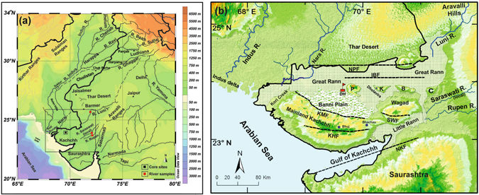
 (a) Regional drainage pattern for the western continental margin of the Indian plate. Dotted lines are the paleochannels of the Vedic Saraswati River after Ghose et al.11 and Kar and Ghose48. The box represents the area shown in b. Location of the Dhordo core site and river sediment samples analyzed are also shown. (b) Geomorphic setting of the Great Rann of Kachchh (GRK) basin with surrounding hinterland and core locations. NPF- Nagar Parkar Fault, IBF- Island Belt Fault, KMF- Kachchh mainland Fault, KHF- Katrol hill Fault, NKF- North Kathiawar Fault, SWF- South Wagad Fault, P- Pachham Island, K-Khadir Island, B- Bela Island and C- Chorar Island. Core location: DH- Dhordo core raised from central GRK basin. Maps were prepared using a licensed copy of Ocean Data49 View (https://odv.awi.de/).


Abstract
The lost Saraswati River mentioned in the ancient Indian tradition is postulated to have flown independently of the Indus River into the Arabian Sea, perhaps along courses of now defunct rivers such as Ghaggar, Hakra and Nara. The persistence of such a river during the Harappan Bronze Age and the Iron Age Vedic period is strongly debated. We drilled in the Great Rann of Kachchh (Kutch), an infilled gulf of the Arabian Sea, which must have received input from the Saraswati, if active. Nd and Sr isotopic measurements suggest that a distinct source may have been present before 10 ka. Later in Holocene, under a drying climate, sediments from the Thar Desert probably choked the signature of an independent Saraswati-like river. Alternatively, without excluding a Saraswati-like secondary source, the Indus and the Thar were the dominant sources throughout the post-glacial history of the GRK. Indus-derived sediment accelerated the infilling of GRK after ~6 ka when the Indus delta started to grow. Until its complete infilling few centuries ago, freshwater input from the Indus, and perhaps from the Ghaggar-Hakra-Nara, probably sustained a productive marine environment as well as navigability toward old coastal Harappan and historic towns in the region.

Yog  .

See also :
The Chronology of Puranic Kings and Rigvedic Rishis in Comparison with the Phases of the Sindhu–Sarasvati Civilization
Michel Danino on Sarasvati  

Wednesday, 12 July 2017

Too early to settle the Aryan migration debate?

G.Chaubey

K. Thangaraj


With genetic data currently available, it is difficult to deduce the direction of migration either into India or out of India during the Bronze Age 


On June 17, The Hindu published an article by Tony Joseph (“How genetics is settling the Aryan migration debate”) on current genetic research in India and stated that “scientists are converging” on the Aryan migration to the Subcontinent around 2000-1500 BC. This conclusion was mainly based on the results obtained from the paternally inherited markers (Y chromosome), published on March 23, 2017 in a scientific journal, BMC Evolutionary Biology, by a team of 16 co-authors including Martin P. Richards of the University of Huddersfield, which compiled and analysed Y chromosome data mainly from the targeted South Asian populations living in the U.K. and U.S. However, anyone who understands the complexity of Indian population will appreciate that Indians living outside the Subcontinent do not reflect the full diversity of India, as the majority of them are from caste populations with limited subset of regions.

Under-representation

A recent paper by Dhriti Sengupta and colleagues (‘Genome Biology and Evolution 2016’; 8:3460-3470), showed that the South Asian populations included in the “1000 Genomes Project” under-represent the genomic diversity of the Subcontinent. Tribes are one of the founding populations of India, any conclusion drawn without studying them will fail to capture the complete genetic information of the Subcontinent.

Marina Silva/Richards et al. argued that the maternal ancestry (mtDNA) of the Subcontinent is largely indigenous, whereas 17.5% of the paternal ancestry (Y chromosome) is associated with the haplogroup R1a, an indication of the arrival of Bronze Age Indo-European speakers. However, India is a nation of close to 4,700 ethnic populations, including socially stratified communities, many of which have maintained endogamy (marrying within the community) for thousands of years, and these have been hardly sampled in the Y chromosome analysis led by Silva et al., and so do not provide an accurate characterisation of the R1a frequencies in India (several tribal populations carry substantial frequency of haplogroup R1a).

Equally important to understand is that the Y chromosome phylogeny suffered genetic drift (lineage loss), and thus there is a greater chance to lose less frequent R1a branches, if one concentrates only on specific populations, keeping in mind the high level of endogamy of the Subcontinent. These are extremely important factors one should consider before making any strong conclusions related to Indian populations. The statement made by Silva et al. that 17.5% of Indians carry R1a haplogroup actually means that 17.5% of the samples analysed by them (those who live in U.K. and U.S.) carry R1a, not that 17.5% of Indians carry R1a!

Genetic affinities

Indian genetic affinity with Europeans is not new information. In a study published in Nature (2009; 461:489-494), scientists from CSIR-Centre for Cellular and Molecular Biology (CCMB), Hyderabad, and Harvard Medical School (HMS), U.S., using more than 5,00,000 autosomal genetic markers, showed that the Ancestral North Indians (ANI) share genetic affinities with Europeans, Caucasians and West Asians. However, there is a huge difference between this study and the study published by Silva et al., as the study by CSIR-CCMB and HMS included samples representing all the social and linguistic groups of India. It was evident from the same Nature paper that when the Gujarati Indians in Houston (GIH) were analysed for genetic affinities with different ethnic populations of India, it was found that the GIH have formed two clusters in Principal Component Analysis (PCA), one with Indian populations, another an independent cluster. Similarly, a recent study (‘Neurology Genetics’, 2017; 3:3, e149) by Robert D.S. Pitceathly and colleagues from University College of London and CSIR-CCMB has analysed 74 patients with neuromuscular diseases (of mitochondrial origin) living in the U.K. and found a mutation in RNASEH1 gene in three families of Indian origin. However, this mutation was absent in Indian patients with neuromuscular diseases (of mitochondrial origin). This mutation was earlier reported in Europeans, suggesting that these three families might have mixed with the local Europeans; highlighting the importance of the source of samples. Another study published in The American Journal of Human Genetics (2011; 89:731-744) by Mait Metspalu and colleagues, where CSIR-CCMB was also involved, analysed 142 samples from 30 ethnic groups and mentioned that “Modeling of the observed haplotype diversities suggests that both Indian ancestry components (ANI and ASI) are older than the purported Indo-Aryan invasion 3,500 YBP (years before present). As well as, consistent with the results of pairwise genetic distances among world regions, Indians share more ancestry signals with West than with East Eurasians”.

We agree that the major Indian R1a1 branch, i.e. L657, is not more than 5,000 years old. However, the phylogenetic structure of this branch cannot be considered as a derivative of either Europeans or Central Asians. The split with the European is around 6,000 years and thereafter the Asian branch (Z93) gave rise to the South Asian L657, which is a brother branch of lineages present in West Asia, Europe and Central Asia. Such kind of expansion, universally associated with most of the Y chromosome lineages of the world, as shown in 2015 by Monika Karmin et al., was most likely due to dramatic decline in genetic diversity in male lineages four to eight thousand years ago (Genome Research, 2015; 4:459-66). Moreover, there is evidence which is consistent with the early presence of several R1a branches in India (our unpublished data).

The Aryan invasion/migration has been an intense topic of discussion for long periods. However, one has to understand the complexity of the Indian populations and to select samples carefully for analysis. Otherwise, the findings could be biased and confusing.

With the information currently available, it is difficult to deduce the direction of haplogroup R1a migration either into India or out of India, although the genetic data certainly show that there was migration between the regions. Currently, CSIR-CCMB and Harvard Medical School are investigating a larger number of samples, which will hopefully throw more light on this debate.

Tony Joseph responds:

There is a technical point in suggesting that the South Asian populations included in the “1000 Genomes Project” under-represent the complete genomic diversity of the Subcontinent and, therefore, the 17.5 % R1a frequency the ‘BMC Evolutionary Biology’ study arrived at may not be precise.
That a sample under-represents the complete genomic diversity of India could be said of virtually any study whatsoever, including the studies that the authors of the rejoinder have done. The point about the Marina Silva/Martin P. Richards et al. study is that its conclusions about the chronology of multiple migrations into South Asia are not dependent upon the precise percentage of R1a population — they remain robust whether the R1a percentage is 12.5 % or 17.5% or 22.5 %. The precision of the percentage or the impugned under-representation would have been an issue if the study were to make detailed conclusions about, say, how the Bronze Age migrations spread across different regions in India. Since it is not doing that, under-representation ceases to be a material issue.
In an email to me on May 29, weeks before my article was published, this is what Prof. Richards said about the sample: “It’s true that some of the 1000 Genomes Project (1KGP) sequences that we analysed for genome-wide and Y-chromosome data were sampled from Indians in the U.K. and U.S., and lack tribal groups, which might well be an issue for a detailed regional study of the subcontinent (our mtDNA database was much larger). But we are simply looking at the big picture across the region (what was the role of Palaeolithic, Neolithic and Bronze Age settlement, primarily) and the signals we describe across the five 1KGP sample sets are clear and consistent and also fit well with the lower-resolution data that has been collected in the past (e.g. for R1a distributions). By putting everything together, we feel the sketch of the big picture that we propose is very well supported, even though there will certainly be a huge amount of further analysis needed to work through the regional details.”
The second argument that the rejoinder makes, as summed up in its last paragraph, is that ‘Out of India’ is a possible explanation for the genetic spread that we observe. This is helpful insofar as it accepts that the genetic spread that we observe does need an explanation. But the problem with proposing ‘Out of India’ as that explanation is the following: it is not as if the ‘Out of India’ hypothesis is new; it has been around for decades. But the rejoinder makes no reference to a single peer-reviewed genetic study that makes a serious case for ‘Out of India’.
If the hypothesis were tenable at all, shouldn’t there have been many peer-reviewed papers by now making the case and fleshing out the details?

 K. Thangaraj is with the CSIR-Centre for Cellular and Molecular Biology, Hyderabad, and G. Chaubey is with the Estonian Biocentre in Tartu, Estonia

Tony Joseph is a writer and former editor of ‘BusinessWorld’. Twitter: @tjoseph0010

Yog.

See also :
Genetics and the Aryan invasion debate