Search This Blog

Tuesday, 28 November 2017

Counter-intuitive influence of Himalayan river morphodynamics on Indus Civilisation urban settlements

In truth nothing new . As a friend of mine pointed me in short : 
'' ...they confirm the date of 8000 BP for the shift of the Sutlej. ''

Counter-intuitive influence of Himalayan river morphodynamics on Indus Civilisation urban settlements
Ajit Singh, Kristina J. Thomsen, Rajiv Sinha, Jan-Pieter Buylaert, Andrew Carter, Darren F. Mark, Philippa J. Mason, Alexander L. Densmore, Andrew S. Murray, Mayank Jain, Debajyoti Paul & Sanjeev Gupta
 Abstract  
Urbanism in the Bronze-age Indus Civilisation (~4.6–3.9 thousand years before the present, ka) has been linked to water resources provided by large Himalayan river systems, although the largest concentrations of urban-scale Indus settlements are located far from extant Himalayan rivers. Here we analyse the sedimentary architecture, chronology and provenance of a major palaeochannel associated with many of these settlements. We show that the palaeochannel is a former course of the Sutlej River, the third largest of the present-day Himalayan rivers. Using optically stimulated luminescence dating of sand grains, we demonstrate that flow of the Sutlej in this course terminated considerably earlier than Indus occupation, with diversion to its present course complete shortly after ~8 ka. Indus urban settlements thus developed along an abandoned river valley rather than an active Himalayan river. Confinement of the Sutlej to its present incised course after ~8 ka likely reduced its propensity to re-route frequently thus enabling long-term stability for Indus settlements sited along the relict palaeochannel.

From the paper : 


This finding resolves a question that has been debated for well over a hundred years. Our analysis shows that the Ghaggar–Hakra palaeochannel is a former course of the Himalayan Sutlej River that formed and occupied an incised valley from at least ~23 ka (Fig. 10a). Initial abandonment of this incised valley by the Sutlej River commenced after ~15 ka, with complete avulsion to its present course shortly after ~8 ka. This involved a lateral shift of the Sutlej River by up to 150 km, with the avulsion node located close to the Sutlej exit at the Himalayan front (Fig. 10). While we cannot identify the root cause of this avulsion, its timing after ~8 ka corresponds with the onset of a long phase of decline in the strength of the Indian Summer Monsoon (ISM)77, 78 that may indicate a possible climatic control on river reorganisation. However, it is important to point out that avulsion is an autogenic mechanism and need not mark a response to an external event.
Our study sheds new light on the role of river dynamics on early urbanisation. We find that the locus for the abundant Indus Civilisation urban settlements along the Ghaggar–Hakra palaeochannel was the relict, underfilled topography of a recently abandoned valley of the Himalayan Sutlej River rather than an active Himalayan river. We suggest that this abandoned incised valley was an ideal site for urban development because of its relative stability compared to Himalayan river channel belts that regularly experience devastating floods and lateral channel migration.
and : 
 A significant unresolved issue is that not all urban settlements in the region are necessarily co-located with the Ghaggar–Hakra palaeochannel84. The largest Indus site in the region, Rakhigarhi, widely considered to be of the scale of an Indus city14, 16, 85, is situated at least 50 km from the Ghaggar–Hakra palaeochannel. Although its location has been linked to another abandoned river system, the Drishadvati85, in situ data are necessary to determine the existence and timing of such river activity before drawing inferences on how such sites were sustained.

In conclusion, our results firmly rule out the existence of a Himalayan-fed river that nourished Indus Civilisation settlements along the Ghaggar–Hakra palaeochannel. Instead, the relict Sutlej valley acted to focus monsoon-fed seasonal river flow as evidenced by very fine-grained sediments in the upper part of the valley-fill record. This and the potential to pond flood waters in the topographic depression38 formed by the valley likely offered favourable conditions that led Indus populations to preferentially settle along the incised palaeovalley. We find that river dynamics controlled the distribution of Indus sites in the region, but in the opposite sense to that usually assumed: it was the departure of the river, rather than its arrival, that triggered the growth of Indus urban settlements here. We posit that a stable abandoned valley, still able to serve as a water source but without the risk of devastating floods, is a viable alternative model for how rivers can nucleate the development of ancient urban settlements. 
Yog .

See also : 

The Chronology of Puranic Kings and Rigvedic Rishis in Comparison with the Phases of the Sindhu–Sarasvati Civilization


Wednesday, 22 November 2017

Indus potters in central Oman in the second half of the third millennium BC. First results of a technological and archaeometric study

SOPHIE MÉRY, MICHELE DEGLI ESPOSTI, DENNYS FRENEZ & JONATHAN MARK KENOYER 
Summary
The nature of cultural interactions between the Indus Civilization and Magan is explored in this paper. The presence of Indus potters in eastern Arabia can now be demonstrated based on a combined technological and petrographical study of a range of pottery types found at the site of Salūt ST1 (Sultanate of Oman). Similar discoveries from other Umm an-Nar sites in the Sultanate of Oman and the UAE supports the hypothesis that Indus communities were living alongside the Magan people at Umm an-Nar sites more extensively than previously thought.
Keywords:eastern Arabia, Salūt, Hīlī, technology, pottery, potters 

Yog.

See also :  The Sindhu Civilization Effect: Oman and Bahrain

Wednesday, 18 October 2017

Mohenjo-Daro's Small Public Structures: Heterarchy, Collective Action and a Re-visitation of Old Interpretations with GIS and 3D Modelling

Adam S. Green (a1)

McDonald Institute for Archaeological Research, University of Cambridge, Downing Street, Cambridge CB2 3ER, UK Email: ag952@cam.ac.uk

https://doi.org/10.1017/S0959774317000774 Published online: 09 October 2017

Abstract
Together, the concepts of heterarchy and collective action offer potential explanations for how early state societies may have established high degrees of civic coordination and sophisticated craft industries in the absence of exclusionary political strategies or dominant centralized political hierarchies. The Indus civilization (c. 2600–1900 bc ) appears to have been heterarchical, which raises critical questions about how its infrastructure facilitated collective action. Digital re-visitation of early excavation reports provides a powerful means of re-examining the nuances of the resulting datasets and the old interpretations offered to explain them. In an early report on excavations at Mohenjo-daro, the Indus civilization's largest city, Ernest Mackay described a pair of small non-residential structures at a major street intersection as a ‘hostel’ and ‘office’ for the ‘city fathers’. In this article, Mackay's interpretation that these structures had a public orientation is tested using a geographical information systems approach (GIS) and 3D models derived from plans and descriptions in his report. In addition to supporting aspects of Mackay's interpretation, the resulting analysis indicates that Mohenjo-daro's architecture changed through time, increasingly favouring smaller houses and public structures. Close examination of these small public structures also suggests that they may at times have been part of a single complex.
Yog.  

Friday, 29 September 2017

Manufacturing and trade of Asian elephant ivory in Bronze Age Middle Asia. Evidence from Gonur Depe (Margiana, Turkmenistan)

Dennys Frenez
Department of History and Cultures, University of Bologna, Via San Vitale 28/30, 48121 Ravenna, Italy

A B S T R A C T
This paper presents the detailed stylistic and functional analysis of a large collection of artifacts made from Asian elephant ivory discovered at the Oxus Civilization site of Gonur Depe in southern Turkmenistan. Artifacts in ivory of Asian elephant from Bronze Age sites in Middle Asia have usually been considered as evidence for the import of finished items from the greater Indus Valley. The detailed study of the Gonur Depe ivories has instead proven that there are significant morphological and stylistic differences between these artifacts and those found at contemporaneous sites in the Indus Valley. This evidence raises important questions about the provenance of the raw material and about the origin and training of the craftsmen who manufactured the objects. Detailed research in textual sources about traditional arts and crafts in South Asia and in classical and medieval commentaries about ivory carving, integrated with ethnographic data about skilled crafting in traditional societies,has led to propose new hypotheses about the complex socioeconomic and cultural organization of manufacturing and trade of Asian elephant ivory during the Bronze Age.

Keywords: Ivory Asian elephant Bronze Age Oxus Civilization Indus Valley

Yog

Thursday, 3 August 2017

Large-Scale, Multi-Temporal Remote Sensing of Palaeo-River Networks: A Case Study from Northwest India and its Implications for the Indus Civilisation

Hector A. Orengo 1, and Cameron A. Petrie 2
1 McDonald Institute for Archaeological Research, University of Cambridge, Downing Street, Cambridge CB2 3ER, UK
2 Department of Archaeology and Anthropology, University of Cambridge, Downing Street, Cambridge CB2 3DZ, UK
* Correspondence:
Academic Editors: Nicola Masini and Prasad S. Thenkabail
Received: 6 June 2017 / Accepted: 12 July 2017 / Published: 16 July 2017


 Figure 6. Results of the interpretation of both SMTVI and seasonal multi-temporal spectral decomposition techniques for the reconstruction of the palaeo-hydrological network of the Sutlej-Yamuna interfluve.


 Abstract: Remote sensing has considerable potential to contribute to the identification and reconstruction of lost hydrological systems and networks. Remote sensing-based reconstructions of palaeo-river networks have commonly employed single or limited time-span imagery, which limits their capacity to identify features in complex and varied landscape contexts. This paper presents a seasonal multi-temporal approach to the detection of palaeo-rivers over large areas based on long-term vegetation dynamics and spectral decomposition techniques. Twenty-eight years of Landsat 5 data, a total of 1711 multi-spectral images, have been bulk processed using Google Earth Engine© Code Editor and cloud computing infrastructure. The use of multi-temporal data has allowed us to overcome seasonal cultivation patterns and long-term visibility issues related to recent crop selection, extensive irrigation and land-use patterns. The application of this approach on the Sutlej-Yamuna interfluve (northwest India), a core area for the Bronze Age Indus Civilisation, has enabled the reconstruction of an unsuspectedly complex palaeo-river network comprising more than 8000 km of palaeo-channels. It has also enabled the definition of the morphology of these relict courses, which provides insights into the environmental conditions in which they operated. These new data will contribute to a better understanding of the settlement distribution and environmental settings in which this, often considered riverine, civilisation operated.
Keywords: multi-temporal; seasonal; vegetation; palaeo-river; Indus Civilisation; archaeology

From the paper :

Several relevant results for the reconstruction of the hydrologic history of the northern sector of the study area have been obtained through the use of seasonal vegetation mapping: (1) the confirmation of a major palaeo-course of the later Sutlej river, which contributed to the Ghaggar-Hakra system, though when and for how long remains unknown (top right corner of the lower image in Figure 3); (2) the migration of this same major watercourse from the Ghaggar-Hakra catchment to that of the Sutlej, which would have significantly reduced the amount of water available in the Ghaggar-Hakra’s lower course; and, perhaps most significantly, (3) the multiplication of the palaeo-rivers known in the area, which indicates that as a whole, the region has an extremely complex fluvial history, which will have had important and as yet poorly resolved consequences for water availability and thus also for past human habitation and land-use. SMTVI also allowed study of the morphology of the palaeo-rivers and documentation of multiple avulsion episodes, with consequences for the human habitation and use of the area through which these flowed.

and :
 Our results prove that the factors influencing water availability along the Ghaggar-Hakra basin are much more complex than previously thought. The traces of palaeo-rivers that have been identified cover the entirety of the landscape in the northern sector forming an almost continuous parallel pattern, which points to the changing nature of these channels and the likelihood that floods and river avulsions have been a relative common occurrence. The waters feeding the various palaeo-rivers originated from glacier-fed sources, such as water supplying the various palaeo-rivers related to the Sutlej, which appear to include the main Ghaggar-Hakra channel, as well as monsoonal rain which is likely to have contributed to both perennial and ephemeral rivers (see [10,27,65]). The geographic source of watercourses ranges from the Himalayas to the Aravalli mountains, and seasonal rain patterns and discharge across this zone are very different. All these factors join to create an extremely complex picture in which water availability and location is dependent upon a multiplicity of factors and difficult to predict in the long term.
Yog.

See also :
Finding the Lost Rivers of the Indus Civilisation from Space
Tracing the Vedic Saraswati River in the Great Rann of Kachchh
Counter-intuitive influence of Himalayan river morphodynamics on Indus Civilisation urban settlements
The Chronology of Puranic Kings and Rigvedic Rishis in Comparison with the Phases of the Sindhu–Sarasvati Civilization


Saturday, 29 July 2017

Aryan Migration – From Academics to Politics: An Unfortunate Journey

Krishnendu Das
(Research Scholar, Department of Archaeology, University of Calcutta) 


In his 1947 article “Harappa 1946 : The Defences and Cemetery R -37” British archaeologist Robert Eric Mortimer Wheeler declared that “ The Aryan invasion of the Land of Seven Rivers, the Punjab and its environs, constantly assumes the form of an onslaught upon the walled cities of the aborigines
….On circumstantial evidence, Indra stands accused''. 1 And it was for the first time a linguistic theory found its backbone in archaeology. The theory of a common ancestor of the north Indian languages and the languages spoken in Europe was taking its shape when in the 18 th century Sir William Jones discovered striking similarities between Sanskrit and the European languages. This simple observation gave birth to a theory that some Aryan speaking people invaded the Indian subcontinent around 1500 BC and demolished the Harappan  people and its civilization. But archaeological evidence was still wanting until Sir Robert issued his aforementioned fatwa.
He found a scatter of some 37 unburied skeletons from Mohenjodaro which led him to speculate a slaughter by the Aryan god Indra. In no time, the theory found wide acceptance in the scholarly world. But the situation took a new turn when archaeologist G.F. Dales of the University of Pennsylvania published his ground-breaking findings titled The Mythical  Massacre at Mohenjo-daro in Expedition magazine in 1964
.
Dales, who would later become one of the co-directors of Harappa Archaeological Research Project, showed that these skeletons belong to different stratigraphical levels and were not recovered from the uppermost level of the site. This evidence goes against the Aryan invasion theory because if there were any kind of massacre by some intruders they should have belonged to the uppermost level or the final phase of Mohenjodaro, which was definitely not the case. Moreover some of the skeletons  bore cut-marks which had been healed and it amply proved that the injuries had got nothing to do with their death. And except Mohenjodaro, no such evidence was found from any other site of the Harappan civilization which would establish Sir Robert’s arguments

When the Aryan invasion theory lost its validity, the Aryan migration theory gradually started taking its place. A group of scholars still assume that after the decline of the great Harappan civilization, a group of Indo-Aryan speaking people migrated from central Asia and entered the Indian subcontinent in several waves.2 3 4 The theory says that these Indo-Aryan people pushed Dravidian speaking Harappans towards south India. And the entire north, west and eastern spans of the Indian peninsula were gradually Aryanised within a few centuries. This age-old theory was also based solely on the linguistic assumptions and not properly evidenced by the archaeological parameters. Just like the Aryan invasion theory, the Aryan migration theory also faced stiff challenges since its inception by scholars from as diverse fields as archaeology, anthropology, geology, genetics, linguistics and so on. Recent studies in the above mentioned fields have decidedly showed the utter inharmonious nature of this theory. But the biased minds seem not to care about that. To make things worse, the battle between the invasionist/migrationist and the non-invasionist/migrationist scholars gradually took a shape and form of a  political duel. While Marxist scholars started vouching for the migration theory, the scholars belonging to the nationalist school are upholding an altogether antithetical theory. And a sheer academic debate lost its identity and dignity in the noose of different political agendas. We know that only archaeological evidence can securely unfurl the petals of the remote pasts. Because archaeology gives out the ground reality of the ancient ages from the core of the ground. That is why our history should be written according to the archaeological findings. But in the case of the Aryan migration theory, the whole process that followed was just set upside down. After the proposition of the theory, some illustrious scholars attempted to fit the new archaeological findings in consonants to the Aryan migration theory. To be true, there is nothing in Indian archaeology around 1500BC time period that displays the evidence of any kind of mass migration or several waves of population movement towards South Asia from outside. It was the time when the Harappan civilization was tilting towards its de-urbanised phase. The population movement, which is archaeologically attested during this time period, was from the north-west Indian Harappan territory to the inner India. If the Harappans were Dravidian-speaking people and they were pushed to the modern day south Indian region by the intruding Aryans, one should expect some late Harappan sites in the said region. But the archaeological reality says otherwise as there is no Harappan site beyond Daimabad, which is a late Harappan site of Maharashtra. And this archaeo-reality flings the migrationist scholars to a point of absolute uncertainty.

However, the argument is not enough to combat the enthusiasm of the migrationists. They stick to some old arguments and perhaps intentionally try to give the whole issue a political overtone.
I used the word “intentionally”, because the recent archaeological findings point towards a continuous development and transformation of the Indian civilization and not any kind of invasion/migration. But there is a more specific reason for using this term that warrants some elaboration. It is widely accepted in the scholarly world that the use of the horse was not known to the Harappans and that the horse was introduced in the Indian subcontinent by the invading/migrating Aryan folks. In their 2000 book The  Deciphered Indus Script , Natawar Jha and N. S. Rajaram claimed that they had discovered a lone broken seal with the depiction of a horse from the plethora of the Harappan seals and sealings. But after a close scrutiny it is translucently clear that it was the computer of the claimants which pieced a horse head together with a hind part of a Harappan seal animal. This incident offered a golden opportunity to the migrationist scholars to portray every horse evidence from the Harappan sites as a mere assiduous nationalist or Hindutva endeavour. But in reality, true horse bones were recovered from several Harappan sites belonging to the mature Harappan levels which were securely dated between 2700 BC to the 2000 BC and which had nothing to do with the so called migrations of some fictitious Aryan tribes. Every evidence of horse that was unearthed from a Harappan site dated  before 2000 BC was doubted and the competency of the scholars who identified them were also questioned. A significant incident can be cited in this connection. In a 1974 article 5, A.K. Sharma, an expert in faunal studies, identified the remains of true domesticated horse from the mature Harappan level of Surkotada, a  prominent Harappan site of Gujarat. But Sharma’s claim lacked widespread acceptance as migrationist scholars stamped the specimens as onager or wild ass. After some 20 years, a renowned archaeologist and horse specialist of Hungarian origin, Sandor Bökönyi, came to India and confirmed Sharma’s identification after examining the said specimens.6 The aggrieved Sharma then reacted: “This was the saddest day for me as the thought flashed in my mind that my findings had to wait two decades for recognition, until a man from another continent came, examined the material and declared that ‘Sharma was right’. When will we imbibe intellectual courage not to look across borders for approval? The historians are still worse, they feel it is an attempt on the part of the ‘rightists’ to  prove that the Aryans did not come to India from outside her boundaries.”7

 However, the unrelenting controversy does not end here. Richard Meadow of Harvard University and Ajita Patel were still in very much doubt about the identification, though they failed to convince the Hungarian master Bökönyi.8And for historians and archaeologists in our subcontinent, crying a political conspiracy is perhaps the easiest thing to do when the fault lines of one’s theory get exposed. Even Amartya Sen argued in The Argumentative Indian  citing the example of the attempt of Jha and Rajaram that if a textbook of history displayed the evidence of horse in the Harappan civilization, then it was nothing but a  process of saffronisation. However, one may perhaps expect a scholar of Sen’s stature to be more focused in academic discussions, rather than taking political sides. In reality, scholars having different political inclinations try to interpret a fact in a way that suits their respective political agendas. That’s why migrationist scholars refuse to understand a simple archaeological fact that horse evidences were also very meagre up to the early historical times as in the Harappan civilization sites. And if the remains of the horse had anything to do with the so called Aryan migration, it should have increased immediately after the said incident which is not the case. The other arguments about the Aryan migration were also treated somewhat in an identical manner. Here what is really regrettable is that a purely academic debate was pulled down to a dirty game of politics. We should be more open-minded to accept the archaeological evidences, in whatever form they  present themselves before us. Even today, we don’t know for sure the true nature of the language that was used by the Harappans. It may be the so called Indo-Aryan or Dravidian or an altogether different one, but we have to find the solution in a purely unbiased academic way and not with any kind of preconceived notion. The need of the hour is to safeguard academics from the vicious political interest which tends to take unfair advantage of it and attempt to provoke people in one way or the other. Recent archaeological and anthropological studies point towards a conclusion that there was no incident of any kind of mass migration or a continuous wave of migrations into the Indian subcontinent during the time  period of 2000 to 1500 BC. But we should remember that this theory does not establish the claim of a group of people to be more Indian because of their indigenousness. The criteria of being Indian have been clearly laid down in its constitution. Anyone fulfilling those criteria are Indian and enjoy the rights  provided by it. Our history has no doubt shaped our present, but our present should not be coloured by what happened in the remote past. That is a pure academic concern. Let academics speak for itself.

Yog.
.

Thursday, 20 July 2017

Tracing the Vedic Saraswati River in the Great Rann of Kachchh

Nitesh Khonde, Sunil Kumar Singh, D. M. Maurya, Vinai K. Rai, L. S. Chamyal & Liviu Giosan


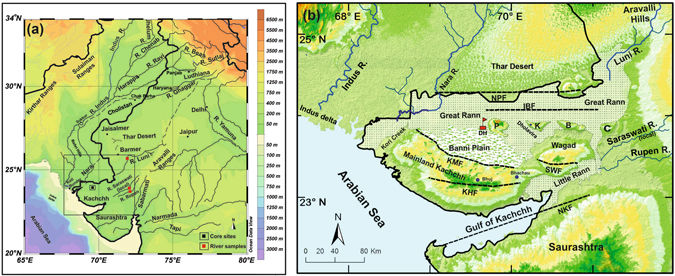
 (a) Regional drainage pattern for the western continental margin of the Indian plate. Dotted lines are the paleochannels of the Vedic Saraswati River after Ghose et al.11 and Kar and Ghose48. The box represents the area shown in b. Location of the Dhordo core site and river sediment samples analyzed are also shown. (b) Geomorphic setting of the Great Rann of Kachchh (GRK) basin with surrounding hinterland and core locations. NPF- Nagar Parkar Fault, IBF- Island Belt Fault, KMF- Kachchh mainland Fault, KHF- Katrol hill Fault, NKF- North Kathiawar Fault, SWF- South Wagad Fault, P- Pachham Island, K-Khadir Island, B- Bela Island and C- Chorar Island. Core location: DH- Dhordo core raised from central GRK basin. Maps were prepared using a licensed copy of Ocean Data49 View (https://odv.awi.de/).


Abstract
The lost Saraswati River mentioned in the ancient Indian tradition is postulated to have flown independently of the Indus River into the Arabian Sea, perhaps along courses of now defunct rivers such as Ghaggar, Hakra and Nara. The persistence of such a river during the Harappan Bronze Age and the Iron Age Vedic period is strongly debated. We drilled in the Great Rann of Kachchh (Kutch), an infilled gulf of the Arabian Sea, which must have received input from the Saraswati, if active. Nd and Sr isotopic measurements suggest that a distinct source may have been present before 10 ka. Later in Holocene, under a drying climate, sediments from the Thar Desert probably choked the signature of an independent Saraswati-like river. Alternatively, without excluding a Saraswati-like secondary source, the Indus and the Thar were the dominant sources throughout the post-glacial history of the GRK. Indus-derived sediment accelerated the infilling of GRK after ~6 ka when the Indus delta started to grow. Until its complete infilling few centuries ago, freshwater input from the Indus, and perhaps from the Ghaggar-Hakra-Nara, probably sustained a productive marine environment as well as navigability toward old coastal Harappan and historic towns in the region.

Yog  .

See also :
The Chronology of Puranic Kings and Rigvedic Rishis in Comparison with the Phases of the Sindhu–Sarasvati Civilization
Michel Danino on Sarasvati